
Pickens County Journalism Since 1999
Early history of Pickens County
By Karen Brewer, Publisher & Editor, The Pickens County Chronicle
This area was inhabited long before Pickens County was officially formed in 1868. The land that is now Pickens County was home to the Cherokee when it was settled in 1743 by Cornelius Keith, a native of Scotland, and his family, who moved from Virginia to what is now the Oolenoy area and traded one of his ponies for land from the native Chief Woolenoy. (The Oolenoy area has been the site of the popular Pumpkin Festival each October since the 1970’s.) In 1791, the Washington District was formed by what is now Greenville, Anderson, Oconee, and Pickens Counties. In 1798, the Pendleton District was formed by what is now Anderson, Oconee, and Pickens Counties. In 1828, the Pickens District was made up of present-day Pickens and Oconee Counties. In 1868, Pickens County and Oconee County were officially formed when each split from the Pickens District to form separate counties. The town of Pickens Courthouse (now referred to as Old Pickens) was relocated to the current site of Pickens. Several buildings were moved from Old Pickens to the new site of Pickens. The James E. Hagood House (now known as the Hagood-Mauldin House) is the only one of those buildings still remaining. It was the home of Frances Hagood Mauldin when she served as the Organizing Regent of the Fort Prince George chapter of the Daughters of the American Revolution (DAR) in 1920. The Hagood-Mauldin House is cared for by members of the Pickens County Historical Society. (One building still remains at the site of Old Pickens, and that is the Old Pickens Presbyterian Church.)
(The above was originally written and printed by the Publisher in a special sesquicentennial publication celebrating Pickens County’s 150th birthday in 2018. A copy of this entire sesquicentennial issue was placed in the time capsule that Pickens County buried at the Pickens County Courthouse in 2018 as part of the County’s sesquicentennial celebration.)
**************************************************
Publisher's note: Sources about Cornelius Keith settling Oolenoy include the following:
the book History of Pumpkintown-Oolenoy, 1970 (written by Bert Hendricks Reece, 1883-1970, organizer of the Oolenoy Development Club and for whom there is a marker at the Oolenoy Community Building, former Oolenoy school) (Please note that this book may be found in the Pickens County Library System at the following locations — Easley headquarters: Historical Collection non check out, SC 975.723 REECE, and Central-Clemson branch: Adult Nonfiction 975.723 REE, and Liberty branch: Adult Nonfiction 975.723 REE)
the book A History of Oolenoy Baptist Church and the Lives of the People Who Have Worked for its Growth, 1995 (written by Ethel Massingill Edens, Evonne Edens Elrod, and Mildred Snow Gilcrease) (Please note that this book may be found in the Pickens County Library System at the following locations — Easley headquarters: Historical Collection SC 286 OOLENOY and Adult Nonfiction 286 OOLENOY, and Central-Clemson branch: Adult Nonfiction 286 OOLENOY, and Pickens branch: Adult Nonfiction 286 OOLENOY.) (This book is listed on the Pickens County Library’s website as Oolenoy Baptist Church and the Lives of the People Who Have Worked for Its Growth)
the book Antebellum Old Pickens District, 2007 (written by Jerry Lamar Alexander, 1937-2018, historian and longtime owner/Publisher of The Pickens Sentinel newspaper) (Please note that this book may be found in the Pickens County Library System at the following locations — Easley headquarters: Historical Collection SC 975.721 ALEXANDER and Adult Nonfiction 975.721 ALEXANDER, and Central-Clemson branch: Adult Nonfiction 975.721 ALEXANDER)
the book Of Keith & Kin, 1987 (written by Marion Freeman Henderson) (Please note that this book may be found in the Pickens County Library System at the following location — Easley headquarters: Historical Collection SC 929.2 KEITH.)
the book Echoes: Oolenoy-Pumpkintown, 1980 (written by Alma Lynch and Elizabeth Ellison, longtime educators) (Please note that this book may be found in the Pickens County Library System at the following locations — Easley headquarters: Historical Collection SC 975.723 LYNCH and Adult Nonfiction 975.723 LYNCH, and Central-Clemson branch: Adult Nonfiction 975.723 LYN, and Liberty branch: Adult Nonfiction 975.723 LYN, and Pickens branch: Adult Nonfiction 975.723 LYNCH.)
the Cornelius Keith historical marker at the Oolenoy Community Center (former Oolenoy school) by the Daughters of the American Colonists
inscription on the gravesite of Cornelius Keith (1715-1808) in the cemetery of Oolenoy Baptist Church (est 1795)
The National Register of Historic Places registration form for Oolenoy Baptist Church cemetery approved by the United States Department of the Interior National Register of Historic Places
The 1825 Robert Mills Map of the Pendleton District (South Carolina State Atlas)
many newspaper articles in The Pickens Sentinel and The Greenville News and in other newspapers, including during Pickens County’s centennial year of 1968 in The Pickens Sentinel, at that time owned by the Hiott family
******************************
******************************
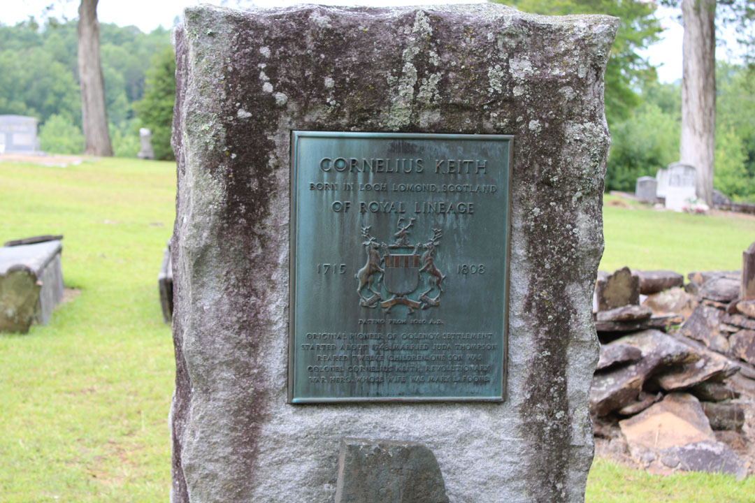
On the plaque at Cornelius Keith's gravesite with the Coat of Arms, dating from 1010 A.D., are these words: "Cornelius Keith born in Loch Lomond, Scotland of royal lineage 1715-1808. Original pioneer of Oolenoy settlement, started about 1743, married Juda Thompson. Reared 12 children. One son was Colonel Cornelius Keith, Revolutionary War hero, whose wife was Mary Lafoone." (Photo by Karen Brewer, The Pickens County Chronicle)
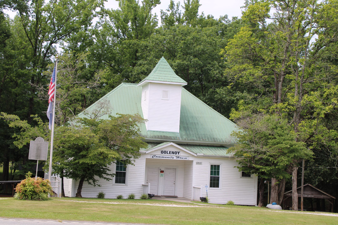
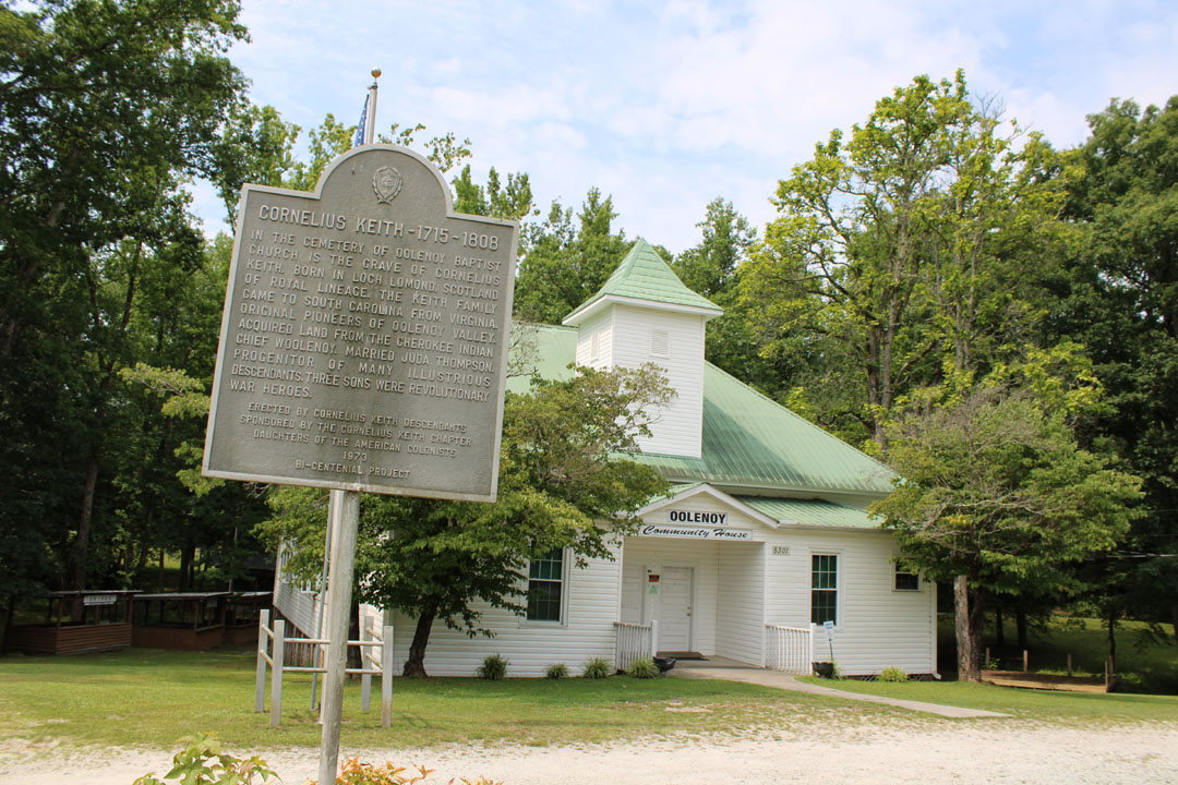
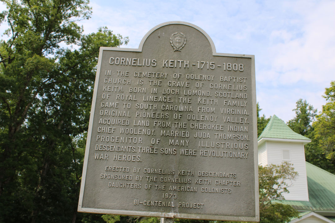
Daughters of the American Colonists historical marker in front of the Oolenoy Community Center (former Oolenoy school) reads: "Cornelius Keith 1715-1808. In the cemetery of Oolenoy Baptist Church is the grave of Cornelius Keith, born in Loch Lomond, Scotland of royal lineage. The Keith family came to South Carolina from Virginia. Original pioneers of Oolenoy Valley. Acquired land from the Cherokee Indian Chief Woolenoy. Married Juda Thompson. Progenitor of many illustrious descendants. Three sons were Revolutionary War heroes." (Photos by Karen Brewer, The Pickens County Chronicle)
******************************
Above is a link to the entire registration form approved by the United States Department of the Interior National Park Service National Register of Historic Places for Oolenoy Baptist Church cemetery. Information below is from page six of that form, which includes information about Cornelius Keith settling the Oolenoy area in 1743.
“The Oolenoy Baptist Church Cemetery, established ca. 1798, is adjacent to the church, on Miracle Hill Road just off S.C. Highway 135 near the Pumpkintown community, in the vicinity of Pickens, Pickens County. It is eligible for listing in the National Register under Criterion A for its significance in Exploration/Settlement for its association with the early settlement of the South Carolina upcountry. It is eligible, furthermore, under Criteria Consideration D as a cemetery deriving its significance from its age, as considered in the context of the settlement, growth, and development of this part of the state and as a cemetery containing the graves of persons of transcendant local importance.
“This cemetery is an excellent example of a typical early nineteenth century to mid-twentieth century church cemetery illustrating vernacular burial customs and gravestone art of the period. It is also significant for its association with Oolenoy Baptist Church, founded in 1795 and the first church established in the Pumpkintown community of Pendleton (later Pickens) District. The cemetery retains a high degree of integrity of location, setting, design, materials, workmanship, feeling, and association and evokes a sense of time and place as a historic church cemetery in the South Carolina upcountry.
“Until after the American Revolution the nearby Woolenoy (later Oolenoy) valley and its environs were populated primarily by the Cherokee and a few white settlers. The Cherokee here were led by a chief named Woolenoy, who called the valley “the land of grain and clear water.” Tradition says that this cemetery was originally a Cherokee burying ground. Cornelius Keith (1715-1808), a native of Scotland who emigrated with his parents to Virginia as a child, brought his wife Juda Thompson and their first child to South Carolina from Virginia in 1743; they were the first white settlers in the valley. Other families, including the Elrod, Edens, Hendricks, Jones, McJunkin, Reid, Roper, and Sutherland families, followed and helped settle the area.”
******************************
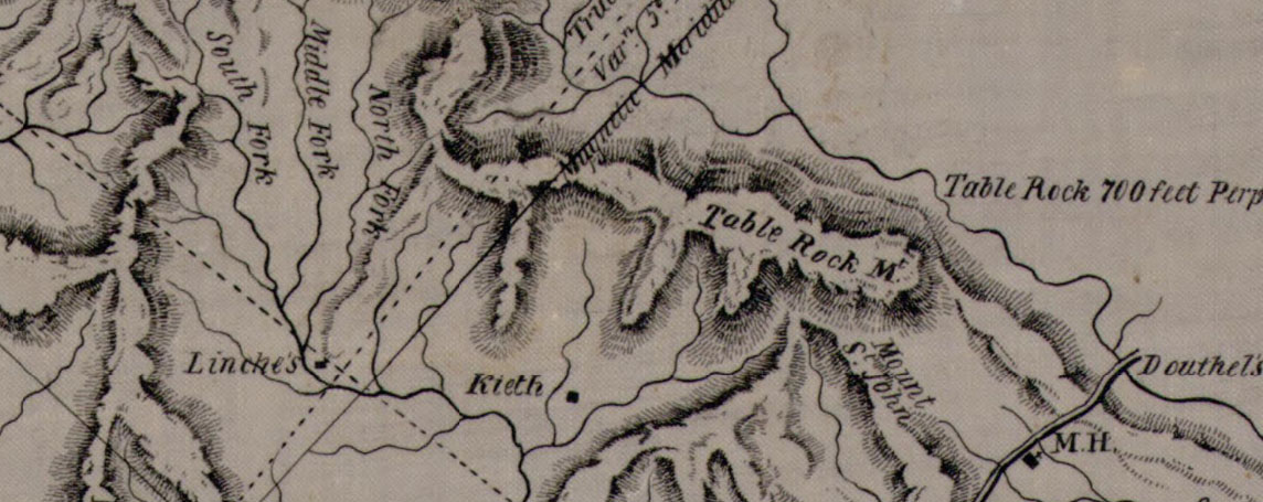
Close-up view of the 1825 Robert Mills Map of the Pendleton District, which may be found on the Library of Congress' website and the South Carolina State Archives. The word 'Kieth' marks the location where Cornelius Keith settled.
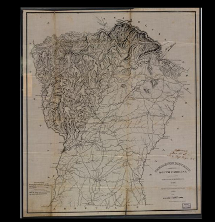
Above is the entire 1825 Mills Map of the Pendleton District, which may be viewed on the Library of Congress' website and the South Carolina State Archives.
Information below about the 1825 Mills Map is from the South Carolina State Archives:
“The 1825 publication of Robert Mills’ Atlas of the State of South Carolina marked an American cartographic first. This volume is the first systematic atlas of any state in the union. Remarkably, too, no other state atlas of South Carolina was published for the next century and a half.
“Nationally noted architect and engineer, South Carolina native Robert Mills received on December 23, 1823 a “sanctioned” (ratified) provisional contract from the General Assembly of South Carolina to publish and sell maps of each of the state’s twenty-eight political divisions known as districts. The agreement authorized Mills’ utilization of state-owned district surveys as a base and in return, the State was to receive free of charge twelve bound editions of the Atlas. In addition, the Superintendent of Public Works was obligated to purchase another fifty copies for $600.00. From 1822 through 1825, Mills redrew the base surveys, converting the larger scales to the atlas standard of two miles to an inch. He added a legend to each map denoting the “geological position,” the bearing and distance from Columbia, longitude and latitude of each county seat, deleted and/or inserted place names and topological features, and standardized the cartographic conventions and typography. The legend of each map bears the original surveyor’s name and notes the map was “improved for Mills’ Atlas, 1825.”
“Engraved and printed in Philadelphia by H. S. Tanner & Assistants, the Atlas was presented to the South Carolina Senate on September 29, 1826. The Senate commended the volume as being a “fine specimen of American Science and Art.” Touted as being better than comparable European publications by the American Farmer, the Atlas and its accompanying volume, Statistics of South Carolina, are still in constant use by historians, ecologists, lawyers and genealogists as invaluable research tools.”